Groundwater is probably not a subject that occupies our thoughts very often. As a science, it is the domain of hydrologists, but this page will hopefully clarify some of the issues affecting our water supply and the threats it faces.
Interactive map of dewatered ponds and wells
 Our map locates the effects of dewatering on our village and shows how they follow the contours of the gravel aquifer. How near is your home to the affected area?
Northstowe – the tragic errors
 Information from the Campaign to Protect Rural England explains the puzzle of how and why blunders were made in the early stages of Northstowe’s development.
Read our take on Northstowe as Shakespearean tragedy
Requiem for a pond
 Water loss is not just an issue for the politicians and developers. It affects people and whole communities. We interview residents whose experiences of dewatering are distressingly personal.
Read our article on the Ladywalk Pond
A Water Loss Timeline
 The Longstanton & District Heritage Society contributes regularly to the village magazine, Longstanton Life. The society has been warning of the dire consequences of dewatering since 2016.
Read a timeline of the warnings that nobody heeded.
The Cam Valley Forum
 The Cam Valley Forum is a voluntary group that takes an interest in the River Cam and its importance for water supply in Cambridgeshire. We particularly recommend reading their document “The River Cam Manifesto” by Stephen Tomkins (it’s a lengthy read!), but their entire website is a treasure house of information about how our environment works.
Visit the River Cam Forum website here.
The Kingfisher Pond – an introduction
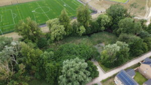
 The Kingfisher Pond is emblematic of the problems affecting the water supply in Longstanton. It was originally created as a source of irrigation water when the whole of present-day Northstowe was still agricultural land. It measures some 75m by 35m, is located adjacent to the Western Park sports area and the allotments in Northstowe. Originally, the water was between 1.5m and 2m in depth.
Read the whole of this article
The Wallingford Reports
 H R Wallingford was commissioned by South Cambs District Council on behalf of Longstanton Parish Council to produce a report on the observed loss of water in the Kingfisher Pond.
Read this article and download the three reports

